SUMMITS
SUMMIT Nº 28 AND Nº 29: GOLEM KORAB
ALBANIA & NORTH MACEDONIA

GOLEM KORAB

25/09/2025
ALTITUDE
2.764 m

Nil López, Albert López, Miquel López AND Andreu López

DIFFICULTY LEVEL
MEDIUM
CHRONICLE
Last year, the trip to the Czech Republic, which marked the 18th summit of the project, Snezka (1,603 meters), had a special symbolic meaning for me as it marked the entry and debut of my three nephews in the project. The young people weren’t entirely disliked, so we suggested continuing the topic, and the discussion led us to Albania.
Albania is a country located in southeastern Europe with a population of nearly 3 million. Its capital is Tirana, with approximately 800,000 inhabitants. It lies on the Adriatic and Ionian Seas within the Mediterranean Sea and shares land borders with Montenegro to the northwest, Kosovo to the northeast, North Macedonia to the east, Greece to the south, and a maritime boundary with Greece, Montenegro, and Italy to the west. After World War II, Albania aligned itself with the communist bloc and was a socialist state (the People’s Socialist Republic of Albania) from January 1946 to 1992. From 1992 to the present, Albania has been governed by a representative democratic parliamentary republic.
Having broadly outlined both geographically and historically our host home for the next few days, let’s get to the point where the plane is slipping away. Meet Team L:
Nil López Codina: the “big brother.” Lately, he’s been talking to me about snorkeling, freediving, scuba diving, and various maritime terminology that has nothing to do with the activity of ascending, which is what mountaineering and hiking consist of. But hey… he’s the most responsible of the three, so we’ll trust him completely. On a more serious note, he’s the real “boss” of the trip, who diligently organized all the logistics of hotels, cars, and the tour program, among other things, and was able to give his uncle, who happens to be the person writing these lines, a break.
Albert López Codina: “in the middle.” A digital nomad, disruptive, entrepreneurial, daring, different… a “salmon,” as I say, with a powerful aura of transformation and change surrounding him. While the “older brother,” from now on Nil, has been fully involved in the trip, to balance it out, he has been fully involved. He hasn’t set foot on a mountain for weeks due to a knee problem, but to be fair, I also have complete trust in him.
Miquel López Codina: “el benjamín”. Tiene más peligro que la dinamita y con esto, está todo dicho. Color rojo. Persona curiosa, atenta, exploradora…un superdotado del cálculo, con una rapidez y agilidad por los números brutales. Como buena esponja que es, tomando siempre nota de sus dos hermanos, de su tío y de todo lo que le rodea, para el día de mañana encontrar su propio sendero. En las últimas semanas, vaya que casualidad, tampoco no ha pisado una montaña por aquello que dicen que no hay 2 sin 3. He tenido ocasión de compartir montaña con él en un par de ocasiones y tiene muy buena condición si bien le falta lo más importe: la motivación. Le gusta la montaña únicamente como práctica ocasional.
Andreu López Castellano: el “tio”, el impulsor del proyecto. Para más información del personaje consultar la sección “Expedición” de la web topsummitsoftheworld.com.
Paso con mi vehículo a buscar a Albert y Miquel por su domicilio y salimos des de nuestro pueblo de origen Sant Martí de Tous poniendo rumbo al aparcamiento de AENA en la T1. Des de la T1 cogemos un bus con conexión a la T2 donde nos espera Nil quién ya ha facturado su equipaje en los mostradores de Wizz Air. Pasamos los controles de seguridad del aeropuerto con cierta celeridad dado que volamos tarde (a las 22:30) y hay poca afluencia de personas. Dado que tenemos unas 2 horas de margen hasta la partida ponemos un poco de comida en el estómago. Finalmente salimos con una hora de demora, a las 11:30, debido a que las tormentas han demorado los vuelos.
Sobre las 2:00 de la madrugada ponemos los pies en territorio albano. Los diferentes trámites por completar: recogida del equipaje facturado por Nil, compra de tarjetas eSIM para los móviles dado que en Albania el servicio de “roaming” no es gratuito (Albania no forma parte de la Unión Europea si bien inició negociaciones en el año 2022 para su ingreso en el año 2029), cambio de euros a la moneda local “lek”, recogida del vehículo Ford Kuga en las oficinas de Europcar, desplazamiento y “check-in” en el hotel… nos demoran la hora de cerra las persianas hasta las 4:00 de la madrugada. La agenda turística de mañana no se encuentra cargada con exceso así que somos generosos con la hora de reunión en el “hall” del hotel: las 11:00.

Let’s play the game! We begin our Albanian journey by discovering the capital, Tirana, which honestly takes two to three hours to complete. Sixty percent of the country is Muslim, so the capital’s attractions include visiting some mosques, the central market, and some buildings from the socialist era, and there’s little else to explore.
Given that tomorrow promises to be a busy day with the climb up Mount Korab, we decide not to extend our stay in Tirana and head for the town of Radomire, about a three-hour drive away. The driver is Nil, which I think is fantastic, and I haven’t hidden the fact in other articles that I’m not a big fan of driving. So I step aside and put on “Luís Moya’s” helmet.
We arrive relatively early in the town of Radomire, around 6:30 p.m. During the three-hour drive there, we discovered that Albanian driving is a mix of aggressive, chaotic, and selfish, so as the “presi” says, we’ll have to “be on our toes.”
Nil made a very good choice with the accommodation in Radomire (in fact, he will with all the accommodations on the trip), as it’s located at the foot of the mountain, and the starting point of Trail 9 to Mount Korab. The facilities are superb, with very comfortable beds, and the service from the accommodation staff is exquisite and very generous. Tomorrow the alarm clock will ring early, at 6:30 a.m. to be precise, so around 10:00 p.m. we retire to our rooms. In my case, I’m not going to bed, as I’m immersed in Sergi Unanue’s gripping story “The Path of the Clouds” – 1,700 kilometers on foot along the Great Himalayan Trail. Sergi is a journalist who left his job in Betevé to live a nomadic life. On this 99-day adventure, he crosses the great Himalayan mountain range on foot, from east to west. His trail runs through Nepal, the country with the largest number of eight-thousanders, with a total of eight: Kanchenjunga, Makalu, Lhotse, Everest, Cho Oyu, Manaslu, Annapurna, and Dhaulagiri.
It’s 6:30 a.m. and it seems Spain isn’t the only country experiencing “blackouts.” The power is out throughout the lodge, as well as in the village, although natural light is starting to be enough to distinguish between what we eat and what we don’t. The hotel manager, super friendly, allows us to prepare a picnic with our breakfast, so we grab some slices of bread, cover them with Nutella, and run…correctly, in our case, to walk.
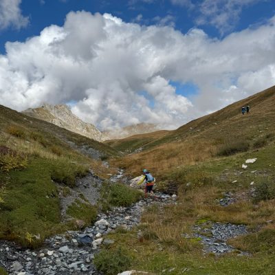
We leave Radomire at 7:00 a.m. and ahead of us lie 21 kilometers with more than 1,500 meters of elevation gain. The ascent will be along Trail 9, which runs through Albanian territory, covering a distance of 9 kilometers to the summit. And the descent is a question mark, with the options under discussion:
- a linear route and returning via the same trail as the outward journey, or
- a circular route and returning via trail 9.1, which progresses along the North Macedonian side and, while longer at 13 kilometers, has a gentler gradient.
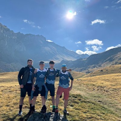
I’d always read that the highest dropout rate in long-distance mountain races occurs among those aged 20 to 29, due to overestimating their capabilities and not economizing their strength. Miquel and Albert attest to this, hitting the Albanian trails like lightning, which already present significant gradients from the start, while Nil, along with the author of these lines, lags further behind. Mountain experience, common sense, and the fact that in the mountains, all four of us must function as a unit with a common goal, lead me to recommend that you slow down and not stray too far from the members at the back of the group.
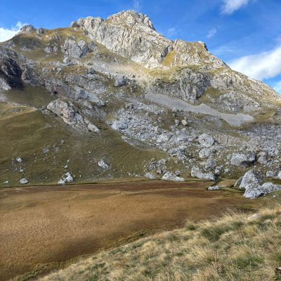
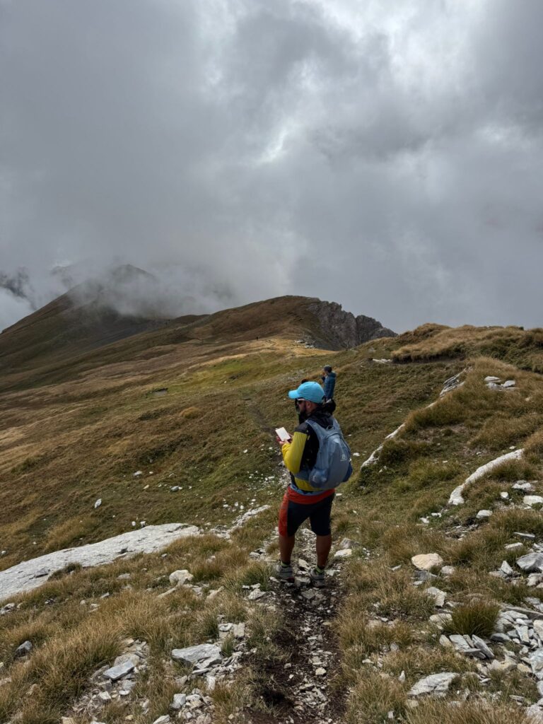
The landscape is treeless, but it does feature beautiful green meadows captured from above by Albert’s drone. As we progress to the summit, we take an initial break at the 1,750-meter mark, which represents one-third of the elevation gain to be completed. There, we chat with a fairly large group of Israelis completing a multi-day trek through the Albanian mountain ranges (among so many international mountaineering experiences, I’ve somewhat forgotten about mountain crossings, although several are still very much on my list of goals, such as the Pacific Crest Trail, the Tour du Mont Blanc, and, why not, the Great Himalayan Trail).
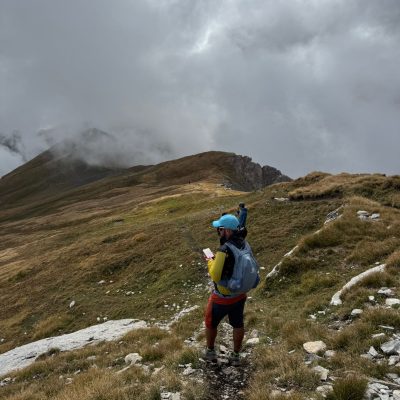
We resume our march as rain forecast for 2:00 p.m. is approaching, and threatening clouds are beginning to approach from the valley floor. The trail gradually gains altitude, without steep slopes, nor any difficulties or technical or risky steps. We set our next objective, which will have a reward in the form of a Nutella sandwich, at the 2,200-meter mark (two-thirds of the climb’s elevation gain), and we reach this point without too much delay, given the group’s good pace. From there, at the 2,200-meter mark, the game is clear: our route/path takes on a U-shape, in which we must first reach a hill and then continue parallel to where we came from, albeit at a higher altitude.
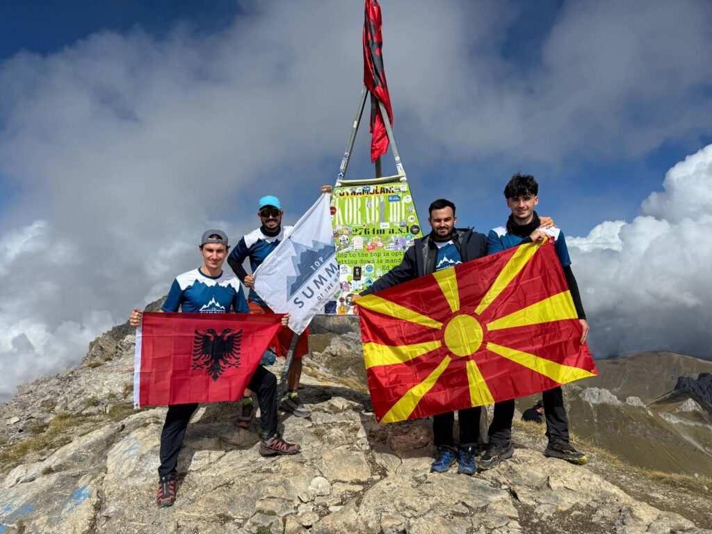
The views from the hill are spectacular, and our eyes are puzzled as to where to look. The valley that opens up behind us, with the clouds pushing upwards, is spectacular. On the other side of the pass, we can see territory owned by North Macedonia, while to our left, only about 250 meters above sea level, we can see the summit of Mount Korab, the national peak shared by Albania and North Macedonia.
Albert’s knee is starting to complain. The elevation gain to be completed today is considerable, and he probably has a problem that will prevent him from engaging in intense physical activities like today’s without compromising his health. There’s not much left, and he’s going to reach the summit, although he’ll have to carefully monitor what’s wrong with his knee.
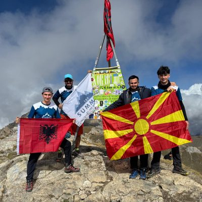
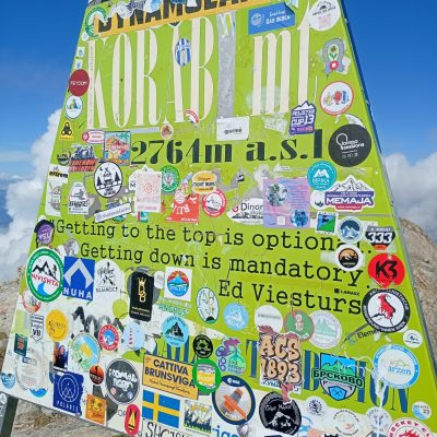
The final part of the climb is very beautiful, with a straight path to the summit, with views of Albania to the left and threatening clouds, as well as views of North Macedonia to our right, without threatening clouds, giving us a clear clue as to where the best way to descend is. But the descent is in the future, and life is lived in the here and now, in the present. The metal panel in the shape of an isosceles triangle indicating that we are on Mount Korab, at an altitude of 2,764 meters, is before us. Written on it is a quote by Ed Viesturs that resonates deeply with me and is one to remember for a lifetime, for a lifetime as a mountaineer: “Getting to the top is optional. Getting down is mandatory.”
")
The part of the trail we ascended remains considerably cloudy, and descending on the other side will allow us to discover new landscapes. The young people, although not keen on extra work, “buy” my arguments, and we descend along Trail 9.1, which initially runs through North Macedonia. The 13 kilometers seem a bit long, since after arriving in Radomire at 4:00 p.m., we will have covered about 21 kilometers and 3,000 meters of accumulated elevation gain, which for someone unfamiliar with the mountains represents a significant challenge. The L team responded perfectly, and we hope the toll, especially for Albert’s knee, will not be too high.
The non-motorized planning is over for today, although the motorized planning is not yet complete, and Nil will still have to drive about four hours to the city of Berat. Berat, declared a World Heritage Site by UNESCO in 2008, is a must-see stop on your trip to Albania. Known as “the city of a thousand windows” or “the museum city” during the communist regime, it is especially beautiful at night, offering a stroll along both sides of the river while enjoying the illuminations of its various buildings.
Another stop you should make is Permet, famous for its whitewater and the canyon through which the Vjosa River flows. Our choice was to enjoy large waves, strong currents, narrow passages, and crystal-clear waters, which we enjoyed on a two-hour rafting trip along a route of approximately 9 kilometers.
We swapped the fresh water of Permet for the salt water of Sarande. Sarande is a tourist center on the Albanian Riviera; the town is located in a horseshoe-shaped bay, lined with beaches and a promenade. In Sarande, you can find accommodation, leisure, and food options with very favorable value for money, although for beaches, it’s advisable to detour to towns about a 30-minute drive away, such as Ksamil, with its beautiful fine sand beaches.
We rounded out the trip by getting to know Albania’s nightlife, its bars, its people, and its local drink: raki. This last one must not have been so good for my body, as it gave me a return to my homeland that I’d rather tell you about than nothing.
I’m super happy with this second chapter of Top Summits, written in a “familiar” handwriting, which allowed us to discover Albania and reach the summit of Mount Korab, this two-in-one peak. The story of travels and summits around the world continues to accumulate pages and chapters, as many as 29 world peaks, although above all, it accumulates shared stories with people of very different backgrounds, although all of them share an energetic proximity with me.
GALLERY